OLD MAPS / BOOKS
Old Maps Box
See More
Admiral Byrd with the old maps
I joined Admiral Byrd with the old maps to try to discover or solve something, at least the maps match with the description of Byrd..
Longine Watch:
https://flightbirds.net/admiral-richard-e-byrd/
Richard Byrd Bio:
https://m.facebook.com/story.php?story_fbid=402841125179931&id=100063621404429
Império Tártaro ®️
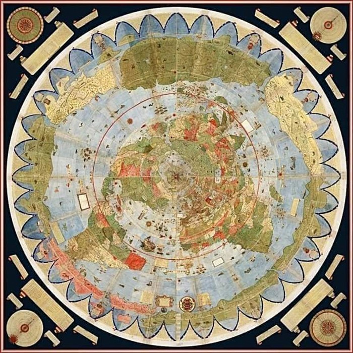
Monte Urbano Map 1587
Terra Australis / Magellanica
(Latin: '"Southern Land'") was a hypothetical continent first posited in antiquity and which appeared on maps between the 15th and 18th centuries.
Its existence was not based on any survey or direct observation, but rather on the idea that continental land in the Northern Hemisphere should be balanced by land in the Southern Hemisphere.
This theory of balancing land has been documented as early as the 5th century on maps by Macrobius, who uses the term Australis on his maps.
Other names for the hypothetical continent have included Terra Australis Ignota, Terra Australis Incognit' ("the unknown land of the south") or Terra Australis Nondum Cognita ("the southern land not yet known").
Other names were Brasiliae Australis ("the southern Brazil"), and Magellanica ("the land of Magellan").
Matthias Ringmann called it the Ora antarctica (antarctic land) in 1505, and Franciscus Monachus called it the Australis orę (Austral country).
In Medieval times it was known as the Antipodes.
During the eighteenth century, today's Australia was not conflated with Terra Australis, as it sometimes was in the twentieth century. Captain Cook and his contemporaries knew that the fifth continent (today's Australia), which they called New Holland, was entirely separate from the imagined (but still undiscovered) sixth continent (today's Antarctica).
In the nineteenth century, the colonial authorities in Sydney re-allocated the name Australia to New Holland and its centuries-old Dutch name eventually disappeared. Meanwhile, having lost its name of Australia, the south polar continent was nameless for decades until Antarctica was coined in the 1890s.
In the early 1800s, British explorer Matthew Flinders popularized the naming of Australia after Terra Australis, giving his rationale that there was "no probability" of finding any significant land mass anywhere more south than Australia.
The continent that would come to be named Antarctica would be explored decades after Flinders' 1814 book on Australia, which he had titled A Voyage to Terra Australis, and after his naming switch had gained popularity.
Legends of Terra Australis Incognita—an "unknown land of the South"—date back to Roman times and before, and were commonplace in medieval geography, although not based on any documented knowledge of the continent.
Ptolemy's maps, which became well known in Europe during the Renaissance, did not actually depict such a continent, but they did show an Africa which had no southern oceanic boundary (and which therefore might extend all the way to the South Pole), and also raised the possibility that the Indian Ocean was entirely enclosed by land.
Christian thinkers did not discount the idea that there might be land beyond the southern seas, but the issue of whether it could be inhabited was controversial.
The first depiction of Terra Australis on a globe was probably on Johannes Schöner's lost 1523 globe on which Oronce Fine is thought to have based his 1531 double cordiform (heart-shaped) map of the world.
On this landmass he wrote "recently discovered but not yet completely explored".
The body of water beyond the tip of South America is called the "Mare Magellanicum," one of the first uses of navigator Ferdinand Magellan's name in such a context.
Schöner called the continent Brasiliae Australis in his 1533 tract, Opusculum geographicum. In it, he explained:
Brasilia Australis is an immense region toward Antarcticum, newly discovered but not yet fully surveyed, which extends as far as Melacha and somewhat beyond.
The inhabitants of this region lead good, honest lives and are not Anthropophagi [cannibals] like other barbarian nations; they have no letters, nor do they have kings, but they venerate their elders and offer them obedience; they give the name Thomas to their children [after St Thomas the Apostle]; close to this region lies the great island of Zanzibar at 102.00 degrees and 27.30 degrees South.
"The Portuguese, thus, sailed around this region, the Brasilie Regio, and discovered the passage very similar to that of our Europe (where we reside) and situated laterally between east and west. From one side the land on the other is visible; and the cape of this region about 60 miles [97 km] away, much as if one were sailing eastward through the Straits of Gibraltar or Seville and Barbary or Morocco in Africa, as our Globe shows toward the Antarctic Pole. Further, the distance is only moderate from this Region of Brazil to Malacca, where St. Thomas was crowned with martyrdom".
Read more 👇
https://www.davidrumsey.com/blog/2017/11/26/largest-early-world-map-monte-s-10-ft-planisphere-of-1587
https://en.m.wikipedia.org/wiki/Terra_Australis
Explorer Ferdinand Magellan
https://m.facebook.com/story.php?story_fbid=365085328955511&id=100063621404429
Império Tártaro ®️
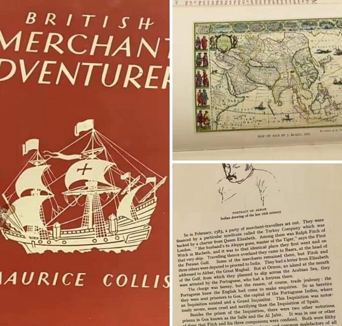
PORTRAIT OF AKBAR Indian drawing of the late 16th century
.
"So in February, 1583, a party of merchant-travellers set out. They were financed by a particular syndicate called the Turkey Company which was backed by a charter from Queen Elizabeth. Among them was Ralph Fitch of London. "Her husband's to Aleppo gone, master of the Tiger," says the First Witch in Macbeth, and it was to that identical place they first went and on that very ship. Travelling thence overland they came to Basra, at the head of the Persian Gulf. Some of the merchants remained there, but Fitch and three others were deputed to proceed to India. They had a letter from Elizabeth addressed to Akbar, the Great Mughal. But at Ormuz, an island at the mouth of the Gulf, from which they planned to slip across the Arabian Sea, they were arrested by the Portuguese, who had a fortress there.
The charge was heresy, but the reason, of course, trade jealousy: the Portuguese knew the English had come to make enquiries. So as heretics they were sent prisoners to Goa, the capital of the Portuguese Indies, where an Inquisition existed and a Grand Inquisitor. This Inquisition was notor- iously severe, more cruel and terrifying than the Inquisition of Spain.
Besides the prison of the Inquisition, there were two other notorious prisons in Goa known as the Salle and the Al Jabir. It was in one or other of these that Fitch and his three companions were confined. Both were filthy underground dungeons in which galley-slaves and common malefactors of all races were crowded together, in stifling heat and without sanitation. Bad as English prisons were at that time they were pleasant places in comparison."
9B
Império Tártaro ®️

.
Factors Explain Motor City's Conflicted Grid - 99% Invisible
American cities tend to follow grid systems, and yet these grids also regularly deviate from predictable patterns in ways that can seem inexplicable at times.
In places like Detroit, one can begin to unpack such complexities and contradictions by examining critical moments in the history of a place.
In turn, understanding the development of one city can.
